Watershed
What makes up the Doan Brook Watershed?
The Doan Brook watershed encompasses about a 12 square mile area in the eastern metropolitan area of Cleveland, Ohio. Over 63,000 human residents call our watershed “home,” as well as numerous species of birds, mammals, pollution-tolerant fish, amphibians, and reptiles. Doan Brook’s three branches form the heart of the Shaker Lakes park system, uniting in the wetlands at the Nature Center at Shake Lakes to flow west and northwest through Rudy Rodgers Memorial Park, Rockefeller Park, the Cleveland Cultural Gardens, and the Cleveland Lakefront Nature Preserve to Lake Erie.
The watershed drains parts of Shaker Heights, Cleveland Heights, and portions of the following Cleveland neighborhoods: Buckeye, Shaker Square, University Circle, Fairfax, Hough, Glenville and St. Clair-Superior.
How has the Watershed Changed?
As the Doan Brook watershed was developed over the last 200 years, the natural water balance has been altered significantly. Natural habitats, primarily forests and wetlands, have been replaced with roads, driveways, parking lots and buildings. These, hard, or impervious surfaces, prevent rainwater from percolating through the soil to ground water.
During heavy rain and snow falls, the volume and velocity of runoff is much higher than in pre-development days, often causing unusually large floods in University Circle. The average annual runoff to the brook is about three times larger than in Nathaniel Doan’s time. The extra watershed area added by the diversion of Giddings Brook, which originally ran directly into Lake Erie, to the Doan Brook sewershed further increases runoff volume.
What is a Watershed?
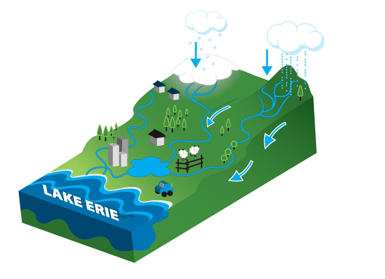
A watershed is an area of land that drains to particular stream, river, lake or ocean. Everyone lives in a watershed!
Basically, watersheds function like a basin, with many starting points that drain downhill to one end point. After a rain or snow fall, water flows over land, draining to the lowest elevation. Small watersheds always form part of a larger watershed; for example, the Doan Brook watershed drains into the Lake Erie watershed, which then becomes the St. Lawrence Seaway watershed, until it reaches the Atlantic Ocean.We like to think of the Doan Brook watershed as our “ecological address.”
What is a Sewershed?
In our urban and suburban landscapes of the Doan Brook watershed, stormwater flow is mixed with a network of sewers, pipes and drains. This infrastructure under our feet connects directly to our local streams, rivers and lakes. This collection of interconnected natural and man-made waterways is called a sewershed. A sewershed is generally related to the surface watershed, but doesn’t need to correspond exactly.
Water that used to run through small tributary streams has been redirected into underground pipes. Water that falls onto roofs is funnelled into downspouts, draining to stormdrains and eventually Doan Brook. Similarly, water that falls onto streets and parking lots drains to stormdrains and eventually Doan Brook. In the City of Cleveland, storm and sanitary sewers are combined. In Cleveland Heights and Shaker Heights, they are separated.